What is Latitude and Longitude?
Just like every actual house has its address (which includes the number, the name of the street, city, etc), every single point on the surface of earth can be specified by the latitude and longitude coordinates. Therefore, by using latitude and longitude we can specify virtually any point on earth.
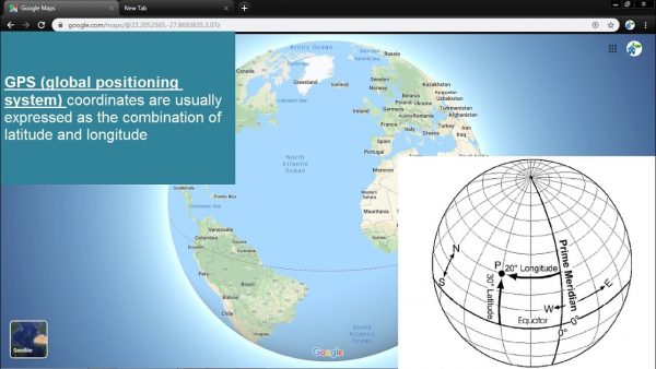
The latitude has the symbol of phi, and it shows the angle between the straight line in the certain point and the equatorial plane. The latitude is specified by degrees, starting from 0° and ending up with 90° to both sides of the equator, making latitude Northern and Southern. The equator is the line with 0° latitude.
The longitude has the symbol of lambda and is another angular coordinate defining the position of a point on a surface of earth. The longitude is defined as an angle pointing west or east from the Greenwich Meridian, which is taken as the Prime Meridian. The longitude can be defined maximum as 180° east from the Prime Meridian and 180° west from the Prime Meridian.
Latitude Longitude What is latitude and longitude? Latitude Longitude is divided into two parts. Latitude is the angular distance of a place north or south of the earth’s equator. The degree of the angle is between -90° and 90°. It is usually expressed in degrees and minutes.
Longitude is the angular distance of a place east or west of the meridian at Greenwich, England, or west of the standard meridian of a celestial object. It is usually expressed in degrees and minutes Coordinates Finder The coordinates finder or coordinate locator will search for longitude and latitude on map. It will also lookup any address by clicking on the map. The result will show on both the map coordinates and on the corresponding fields. The coordinates finder will get latitude and longitude from any address.